OBJECTIVE. IMAGING
Elevation Maps and Orthomosaics - Real Estate Imaging - Crop Health Assessment - Thermal Imaging

ELEVATION MAPS AND ORTHOMOSAICS
Orthomosaic photos are the best means for capturing large areas in ultra-high resolution. Perfect if you need to see a large structure in a resolution greater than you can get from a one fixed camera.
The downside is the difficulty in non-tech focused employees manipulating the massive files generated, but don't worry, our system makes it easy for anyone to take advantage of this technology.
A blend of specialized software a method of teaching that does not add unnecessary complication allows your entire organization to capitalize on tech only available to a select few only years ago.
REAL ESTATE IMAGING
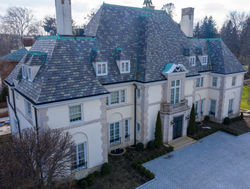
Better cameras, better lenses, better software than your competing agents.
We can incorporate our other technologies like photogrammetry on high dollar listings to set you apart from other agents.
Not only does this make your listing stand out pre-sale but after the close your clients will have a file that any architect or general contractor can read to quickly get exact measurements of any face or surface (take-off) allowing them to generate fast and super-accurate bids for any improvement or renovation work to be done.
Better images and better technology - better listings.


CROP HEALTH ASSESSMENT
NDVI (Normalized Difference Vegetation Index) helps farmers measure the amount of live vegetation in a survey. It's a complex procedure that involves a near infrared laser bouncing off a leaf to determine the amount of chlorophyll produced in a plant. This data is then held against RGB imaging, differences are calculated and we can determine relative health over huge swaths of areas very quickly. This system is complex but our technology makes it ridiculously easy - understanding requires only being able to distinguish red from green.
THERMAL IMAGING
Often will be done as a component of a comprehensive survey or analysis, Objective will gladly be retained to do a stand alone thermal analysis as well.
Ground based and aerial thermal cameras available, large and small scale analysis capabilities.
In the adjacent picture you can see our analysis of an entire town center, a large application. Thermal data can be applied to small scale analysis as well - it's an excellent way to pinpoint loss of HVAC efficiency or even to see in the walls to hunt down a leak without tearing down walls to inspect.


VIDEO
Image sensors that can capture up to 61 MP.
Drones that can shoot in Apple ProRes 4444 or any other desired format. Delivering you the absolute highest fidelity possible.
Pilot Licensing from the FAA allow us to fly both where,
and in manners, most others can not.
Post processing can be done in house or we're happy
to pass the raw files to your Agency.
 |  |  |  |  |  |  |
|---|---|---|---|---|---|---|
 |  |  |  |  |  |  |
 |  |  |  |  |  |  |
